Ski Touring Volcano Lonquimay, Chile

At 2865m volcano Lonquimay in Chile is a decent height volcano to ski or snowboard. It is considered an easier climb in the summer, but it certainly felt a fairly good achievement on a split board in winter via the steeper route we took. It last erupted in 1990 starting on Christmas day 1988, I tried to block out this farily recent eruption and the associated fatalities that resulted, as we plodded up it’s steady steep slopes. The huge lava flows and associated craters from that Christmas in 1990 were visibly behind us slowly getting smaller as we climbed.

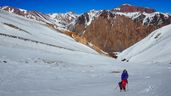
The ascent ridge is exposed near the top and pretty steep so it is not all straightforward. However the approach is stunning, from Temuco you drive through National Park Malalcahuello  with >monkey puzzle tree forests on a jet black road of volcanic gravel. As the snow starts the trees are silhouetted against the imposing volcano rising up above the few ski lifts. The ski resort is called the Corralco-Lonquimay resort, it is pretty flat but the location is probably the most unique you will ever ski so who cares about it being 100% cruisey blues! OLYMPUS DIGITAL CAMERA

We quickly skinned above the lifts and started on the volcano slopes. We passed an old lift base before finding the ascent ridge clearly visible to left in above picture. This is much wider and generally better than it looks however the wind had picked up and was making progress hard. The ski group ahead of use bottled it and skied back down, we progressed, but it involved crawling along. OLYMPUS DIGITAL CAMERA
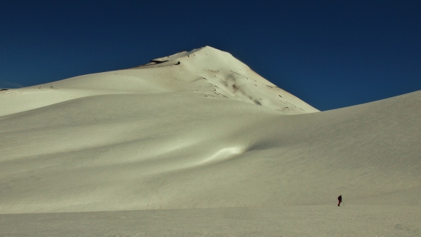
We finally traversed around the cone and started from the other side, it was steeper but no wind. The snow was perfect for boot packing steps up the 35 degree slope. It was exhausting work but finally we crested the icy crater rim.  Collapsed in a heap we admired the view, volcanic cones dotted across the horizon and the plains down to the Pacific Ocean in the west.  OLYMPUS DIGITAL CAMERA

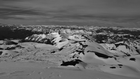
Crater Navidad, and associated lave flows were clearly visible down the slope as per the picture below. The sheer scale of the lava flows and mounds of lava show the scale of the last eruption. Navidad being named after the christmas eruption on 25th December 1988. The landscape really is unique and spectacular. It may look close but it was a long way down, over 1000m of 30 to 35 degree slopes.

OLYMPUS DIGITAL CAMERA

The views across to the other local volcanoes such as Llaima, Villarica and Lanin to the south. All future targets to ski tour!OLYMPUS DIGITAL CAMERA

The ski down was steep but the snow had softened and made a fun ride, with the vastness of the descent it felt you would be down in no time but the steep slope just keeps on going. We cut over to the resort lower down and straight lined the entire resort to carry momentum to the car park. We sat and admired the sun go down after a great day on the volcano. It hadn’t erupted which was a bonus too!OLYMPUS DIGITAL CAMERA

Ski Touring Volcan Antuco, Chile

Volcano Antuco at 2979m was an impressive sight for our next Ski Tour, located in the Laguna del Laja national park in Chile. The access road was as usual a long gravel drive in of about 65km. A few narrow exposed sections but generally the road was fine to drive. At the base is a small ski resort with a couple of drag lifts along the flatter flanks. It seemed to be only open on weekends when we were there.

We arrived on a Saturday night fairly late. We parked up in the camper van just before the park entrance. A strange experience in the pitch black with no idea of our surroundings, the van was rocking violently from some pretty extreme wind, a stream ran past us into what looked like a large lake. The ground was black with old volcanic rock.

A few trucks sped past, one stopped and about 5 guys jumped out, we saw their faces lit up by cigarettes as they sheltered from the wind, for a moment we were afraid of what they were up to. They soon piled back in and sped off into the darkness.

Next day the wind was still battering us. An ascent of the volcano was off. It was way too windy. We explored the park and its setup hiking trails. These were actually pretty stunning. A few information boards told us that a German Botanist, Eduard Poeppig  passed through and sheltered from the locals and the last eruption in 1854. There were huge Coihue trees and big waterfalls.

The road and national park was relatively busy, despite the wind, locals were driving to the small resort and using the drag lifts to ski the gentle slopes.

The next morning the wind had died down and we drove to the resort and soon started skinning up the slopes. It was totally empty not a soul in sight, tumbleweed rolling through the 4 or 5 buildings that marked the resort, in the light wind. We quickly reached the top of the ski lifts. The next section was surprisingly steep, after a few kick turns it was crampons and ice axes out until we reached the defined ridge on the lookers left. The ridge was much mellower. We followed this up to the summit, it got steeper, harder and more exposed but with crampons and axes we were OK. We took shelter from the wind just below the summit cone. The view down to the lake was amazing it was perfectly clear to spot the lava flow curling down the volcano flank and damming the river to create the huge lake after the 1854 eruption.

We then started back down, sadly for us the wind had destroyed the snow. We traversed to the front face away from the ridge we had climbed up, however it was a treacherous ride down, crust and ice on 40 degree slopes for almost 1800m of vertical height, we were scared for each turn. The lower section had softened and let us open up to the base.

A stunning volcano in a stunning setting, a ski touring must.

Exploring Nevados de Chillan Ski Resort and Volcano

Chillan ski resort is about 4 hours south of Santiago. Set in on the slopes of two dominating volcanoes it has some great freeride terrain. We were fortunate to visit on two occasions about 5 weeks apart and both times it had about 15cm of fresh powder. The first visit we skinned from the resort base to the summit of Volcan Chillan about 1700m of vertical height gain. We were given a fair bit of abuse from ski patrol for skinning up on edge of the piste. This annoyed me so we ignored them.

The skin track up is easy but route finding in the various combs of old lava flows can be confusing. We had a blue bird powder day which gave us spectacular views and amzing snow to ski down. We climbed the bare rock of the ‘new’ cone. It is clear of snow due to the heat in the rock which is warm to the touch.

The next day we bought lift passes and rode some of the fun terrain from the slow rickety chair lift. Lots of wide half pipe shaped valleys and plenty of cornice drops to jump.  There was also a few sneaky tree runs which were super fun. In Chile the snowline is generally above the trees so this was about the only time we skied in trees. There are also subtle reminders that this is a volcanoe, with the smell of sulphur and hot steam rising at random spots.  Skiing amoung steam vents and parrots is a little unusual!

The next day we used the lifts and then traversed over to the neighbouring valley, called Aguas Caliente. As the name translate it has various hot water streams converging in steaming deep snow canyons. We hiked up to the highest point to get a run down into the valley through deep untouched powder. It really was the most sunning snowboard I have experienced, as we reached the vally bottom we picked some snow bridges to get to a spot in the stream were we stopped, stripped and jumped into hot water for a soak. Getting out and clothed again was harder. There was also a 400m vertical climb to get out the valley and back down to the resort. We were tired by the end and got little stuck above a waterfall on the way back to resort, all good fun!

On our next visit to the area we were again greeted by fresh overnight powder and rode the resort lifts staying in the campervan parked up in the carpark.

The stunning Rio los Cipreses and Altos del Lircay National Parks

Rio los Cipreses and Altos del Lircay are two of my favourite parks we visited. Both are located in middle Chile and both a bit off the radar, so much so that they were effectively closed when we arrived. Luckily having the Wicked Campervan meant we could drive miles up the backroads and visit them both.

Rio los Cipreses is named unsurprisingly after the mountain Cypress trees that grow there. We arrived at about 7pm pulling up to the locked park gates. The area was surrounded by high fences and secure gates. We had driven in the dark along a wild feeling dirt road darting from small village to hamlet. We crossed large rivers and avoided many stray dogs. All in all the area felt rather uninviting. We decided the only option was to pull in close to the park gate and wait for morning. After we started cooking dinner, at the back of the camper van a chap wanders over from a nearby house, mainly to check us out, also he was surrounded by numerous cats, odd. The scary part was when he told us the area was dodgy “many people with guns, not safe,” erm we have no choice but to park the camper here, he agreed to keep an eye on us. It was going to be long night! Then as if by magic the giant park gates opened, we half expected dinosaurs to escape, but no a middle aged lady in a Honda Civic emerged, we started the van and drove in through the open gates, we had breached the park, another 6km along narrow steep dirt roads and we found the main and only open camp spot.

We awoke to the beautiful birdsong, warm sunshine and prospect of cold showers. We hiked the length of the park admiring cacti, beautiful vistas of snow capped peaks, deep narrow water carved gorges, huge cliff top waterfalls spilling into the air and the enormity of a concrete hydro electric canal . We saw no Cypress trees though!

The campsite came complete with a stray dog. We named him Smokey the campsite dog due to his bear like appearance, he was very lonely and very fluffly. He took a liking to us, sleeping by the van and chasing after us when we left. We felt bad leaving him there, have a look at the pictures to see him looking sad!

Altos del Lircay was a similar situation, the park gates were locked but this time it was 11am, a park warden approached us to inform us the road was closed due to snow. The campsite was inaccessible but this being super friendly CONAF they allowed us to camp up by the visitor centre, with water and toilets left open. The snow depth was about 2m on the giant basalt plateau we wanted to hike. A quick change to ski touring and the next day we climbed up to the deep snow with mind blowing views of the wild never ending snowy Andes. Our only companions on the trip were criss crossing cougar prints in the snow. We reached Lago de Altos and then rode down a sweet couloir back to the snowlin. Boards on back we started the long hike back out to the gate. As fortune had it a CONAF 4×4 was pulling up we hitched a ride in the back as it slid along the rough snowy track. Sketchy but it saved a good 6km hike out!

This park is totally off the radar for ski touring but it shouldn’t be. It has endless possibilities, just look at some of the pictures, remember that this is a bad snow year too!

Snowboarding Chile’s Three Valleys

Snowboarding the three valleys means; El Colorado, la Parva and vallee Nevado.

Each has their own character, El Colorado has good all round terrain, La Parva family orientated and Vallee Nevado short steep slope. The best terrain was down to the Vallee Nevado access road where the Freeride world tour recently used the Santa Theresa  face. We parked the El Colorado camper van in the car park for the entire time we were there, cold but effective.

Hiking Lauca National Park, Chile

After we crossed into Chile we entered the stunning Lauca National Park. We hitched across  the borders no mans land then walked into the park along the quiet road. After about 10km we reached the park guards on the side of lake Chunguara. The view across the lake to the volcanoes was spectacular despite the high altitude taking its toll on us we found the hike wonderful.

We called into the park wardens hut by the lake where there was also a refuge to stay the night. A nice spot to stay but Parinacota village sounded more appealing.

With the altitude we were tired out so hitched a ride. After about 10 minutes we got picked up by huge white lorry. He was carrying Quinoa from near LaPaz to Arica on the coast for export to satisfy the growing western demand. We were dropped off in the middle of nowhere but the Garmin etrex30 GPS I had showed a short cut to Parinacota village. I gave the friendly driver some cash and jumped out of the high cab.

We arrived in the village and the place was empty, tumble weed rolling through the streets and an old man asleep at a small drink stall. We found the park office and refugio but it was locked up. We sat for a while waiting, then visited the old man for some water. It appeared the refuge was permenantly closed despite the park truck outside. Another truck had pulled up and the man was chatting to the other old man. I asked where we could stay and it appeared nowhere was the answer. We hitched a ride out with the other chap who was in a new pickup truck down the valley to the bigger town of Putre. He went way too fast and nearly killed us but was super friendly. Putre was a nice little town on the edge of Lauca National Park with a stunning restaurant serving Alpaca loin, which I enjoyed I lot!

Sajama National park, Bolivia

Sajama National Park in Bolivia is quite simply amazing. It doesn´t feature much in the guide books, it’s pretty hard to reach and generally just too much hassle for most. However this means vast unspoilt landscapes remain surrounded by spectacular mountains, empty hot springs and a real sense of adventure. It really is one of the greatest places I have ever been.

Llama's in Sajama park, Bolivia


Our approach started in Oruro located in the cental altiplano of Bolvia. It was an unexciting and slightly random town, we were there to explore the city but quickly decided to book a bus back out again. The bus we booked was bound for Arica in Chile, but we were planning to hop off in the middle of nowhere and walk or hitchhike into the Sajama national park. In reality we couldn´t quite follow the Spanish instructions at the bus office but it seemed the bus we had booked, didn´t go exactly where we wanted. We had to get a local bus 125km to meet another bus from La Paz at a random road junction and I suspect we paid more for this privilege than the locals! After waiting for an hour in the middle of nowhere we caught the connecting La Paz bus heading to Arica. A kind Chilean man, who is now my facebook friend, translated our plans for getting to Sajama for the driver to understand, so everything was working out just fine. Then we missed the turn off to the park, apparently we could get a taxi easier from Tambo Quebo the border town, I suspect the driver just forgot! After 2 hours waiting for a taxi in Tambo Quebo it seemed walking might have been a better option. Thankfully we were allowed to sit in a telephone booth shop, if that’s the proper name for these places, to keep warm. The border is at 4000m+ so the air is pretty cold as sunset approaches. The warm ‘shop’ was in reality the dodgey border crossing fixer. It was interesting watching, as every 5 minutes another man came in and handed over cash, received cash or received small parcels over the counter. This was clearly the place you could get whatever you wanted in the area. (except a taxi!) Apparently the taxi drivers were all at the Fiesta or something, but finally a local man was tracked down and in the now complete darkness we handed over 100 Boliviano´s to finally get into the park. As I said accessibility for the independent traveler is not straight forward.

Flags flying on the altiplano in Bolivia

The shot below is a stunning sunset over the village of Sajama.
Sunset over the volcanoes in Sajama
After a scary and bumpy ride down a long dirt road we pulled up in a village, it was almost completely dark except for the odd electric light flickering. We entered the only open hostel in the village. A 5 year old boy showed us to our room. We had our own 6 bed dorm in a domed, hobbit like building covered with grass and made with mud brick walls. The en suite had no hot water but was pleasant enough as it avoided a cold late night trip outside! At 4600m the village was rather chilly under the clear and starry sky, not even the bright glare of the perfectly defined Milky Way helped. We brought food with us so chose to decline the hostel dinner on offer. This seemed a lucky escape when we entered the kitchen. I am pretty used to eating at random places and from roadside stalls but this was different, dirty plates everywhere a rack of dead animal parts, bones and a hacksaw for preparing, kids running around and few dirty pans used for cooking. Maybe the altitude prevented bacteria but I was happy as Marion prepared our boring pasta, the other few guests enjoyed their dinner in ignorance of what lurked behind the kitchen door!

Llama's in Sajama National Park, Bolivia

Next day we hiked for about 6km which at that altitude was quite breathless. We arrived at some remote empty hotsprings, with the best view you could possibly imagine, take a look at the photos!

Small mud brick village in depths of Sajama

We walked back between Llamas and volcanoes, visited deserted mud brick villages, saw the odd nomadic looking man aimlessly wandering around.
P8093854
There was another hike we were recommended which was to some geysers and up some hills with great views. Another option is a hike/climb up  Sajama the highest mountain in Bolivia at about 6542m, which we passed on. Apparently the locals had a football game at the top a few years back, so can’t be that bad to climb!
Traffic jam at altitude, Chile and Bolivia border crossing
After a few days staying in and exploring the park we shared a lift back to the border. We then hitched across no mans land to Chile with a kind border official, his car had seen better days so we gave him a few Bolivianos for the ride, retrospectively thinking it is probably not the done thing to give Chilean border officials cash, but never mind. We then hiked into the almost as stunning Lauca national park in Chile, which deserves its own blog post!

Exploring Potosi, Sucre and Oruro, Bolivia

A quick tour of Potosi, Sucre and Oruro three cities that sit proudly on the high Altiplano of Bolivia. Potosi fabled for its silver mines is actually the highest city in the world at 4090m. It has outstanding colonial architecture with a beautiful renovated central square. The square is lined by Potosi cathedral and the Spanish Colonial Mint. The dominating Cerro Rico was rich in silver from 1556 to 1783 about 45,000 tons were mined. The Spanish decimated indigenous labour and imported 1000s of slaves to endure the mines, it is fair to say the history of the city and mines is hard. The current mines are a bit of a tourist attraction where you can go and see what a hard life the miners have, most are drunk or on narcotics it seems. The life expectancy is less than 40. We declined to take a day trip to the mines and instead explored the fascinating streets and buildings. There is a bit of an ethical dilemma here as to whether the ‘extreme’ tourist mine tours help or hinder the progress towards safer conditions.
OLYMPUS DIGITAL CAMERA

There were numerous interesting artisan shops, I purchased some nice warm hand woven Alpaca socks and a fashionable hipster Alpaca jumper. Marion picked up a nice scarf and some woven wall hangings all at very fair and pretty sustainable prices. If we didn’t have 2 months of ski touring ahead we would have bought more of the locally made artisanal textiles.
Cakes in Potosi, Bolivia
Next up was the stunning Colonial Acrhitecture of Sucre, a good spot to take time out and learn Spanish or exploring the surrounding villages. The downtown is well preserved with many interesting buildings. There is also a good sized covered market full of lots of random stuff. We bought a few nice woven items but it was significantly pricer than Potosi. It is also known as the Chocolate capital of Bolivia as the French translation hints at. TO be honest I wasn’t blown away by the chocolates, maybe I just didn’t buy the good stuff though! At 2810m it is not super high but a nice all round cool climate. It felt pretty warm during August i.e. mid winter when we were visiting.
National Day celebrations in Potosi, Bolivia
As the constitutional capital of Bolivia it hosts many interesting buildings such as Sucre cathedral, the national library, The house of freedom and the Archbishops house. All date from colonial times and most share the whitewashed exterior that I felt defines the city.

We were fortunate to time our visit with Bolivia´s national day on 6th August. This meant huge celebrations, many marching bands, a few well dressed dignitaries, military parades and so many versions of the national anthem!

Potosi was hosting a national marching band event, while Sucre was more of an event fitting of its constitutional capital status, with endless marches of endless groups of people. The entire city must have been involved. It went on for literally two days. We came back at 9am after a late night and they were still marching!
OLYMPUS DIGITAL CAMERA
From Sucre we bussed up to Oruru an eight hour ride so we paid a couple dollars more for the cama deluxe bus. It also left at a convenient time. Sadly it had no working toilet, massively bald tyres and generally a scarily worn out. No toilet all night was interesting we had to ask the driver to stop then find spot by roadside, fine for me but Marion found it less tolerable! It was also bit disconcerting trying to sleep on a bus when it is dark outside but the road is twisting and turning up and down some seriously under engineered roads in the Andes all at some great altitude. It was probably best not to see all the roads but then again your imagination runs wild with what was behind the veil of darkness!

Oruru was dull we arrived at 6.30am and decided to leave as soon as possible. We wanted to get direct to Sajama National park, this proved hard, no one would help. We were sent on two wild goose chases to random bus offices around town trying to find a bus. It seemed like one should exist but it was beyond us to find it. We bought a ticket to Arica in Chile then we just had to get off by the border so we could hitch or taxi into the park. The village of Sajama is 15km off the main road so walking at the 4400m altitude is not your best bet. In hindsight getting a local bus to Patacamaya a junction with the La Paz-Arica road would be the best option and getting a ride from there would be possible.

First day of splitboard touring in the Andes

OLYMPUS DIGITAL CAMERA Last week we finally got the snow boards on and had a good day tour in the high Andes. We started at Los Penitentes and then head upto about 4000m. Starting at 2600m and with no aclimatisation it was hard work. OLYMPUS DIGITAL CAMERAThe snow was reminiscent of Scotland but the view of peaks upto the 7000m Aconcagua were not bad. The snow was actually better than it looked the cool temperatures preserving powder in parts and the grip was surprisingly good for what was quite a step skin track.

Below is the resort base, not much snow for mid winter.OLYMPUS DIGITAL CAMERAWe saw no one past the ski resort boundary and ski patrol were super friendly pointing out couloirs we could do.OLYMPUS DIGITAL CAMERA
After riding we headed to the border with Chile there was just a small queue of traffic, maybe 35km long! Luckily our driver overtook them all which was nice but a bit sketchy in the tunnels…OLYMPUS DIGITAL CAMERA

Crossing the wild Altiplano in Bolivia

A rather unexpected twist to our snowboarding trip was ending up in the Altiplano of Bolivia.